

Editor's note: This is the last of six stories for "Colorado River reckoning: Not enough water," an investigative series by the Arizona Daily Star that observes, at length, the future of the Colorado River.
People are also reading…

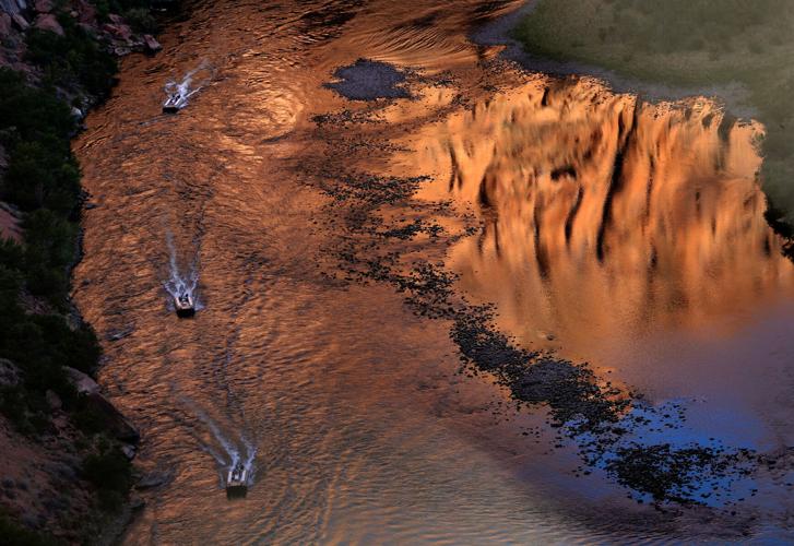
Small power boats head upstream on the Colorado River just below Glen Canyon Dam. In 5 to 10 years, we're likely to pay 60% more than now to bring Central Arizona Project water from the Colorado River to Tucson.

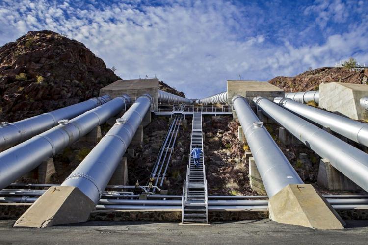
Mark Wilmer Pumping Station on Lake Havasu. The six 66,000-horsepower pumps lift Colorado River water more than 800 vertical feet into Buckskin Mountain Tunnel and the Central Arizona Project canal. Phoenix and Tucson heavily depend on CAP water, with Tucson's drinking water coming exclusively from that canal system.

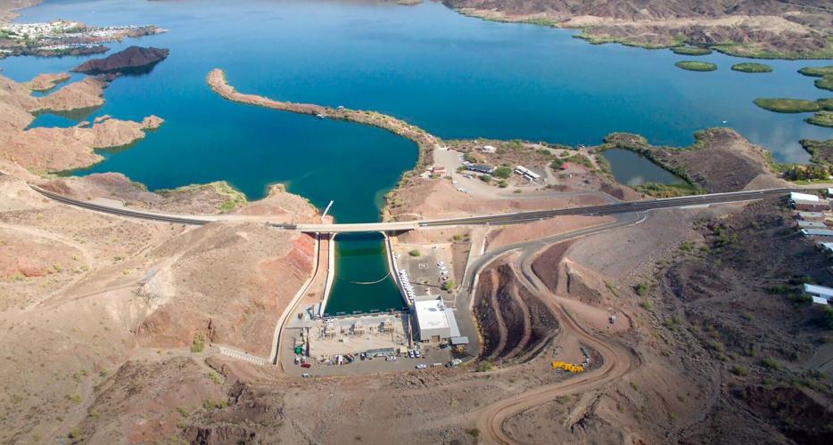
The Whitsett Intake Pumping Plant is the first of five pumping stations that carry Colorado River water over mountains and through the desert and to Southern California faucets. California has the right to the largest single share of Colorado River water for its farms and cities.

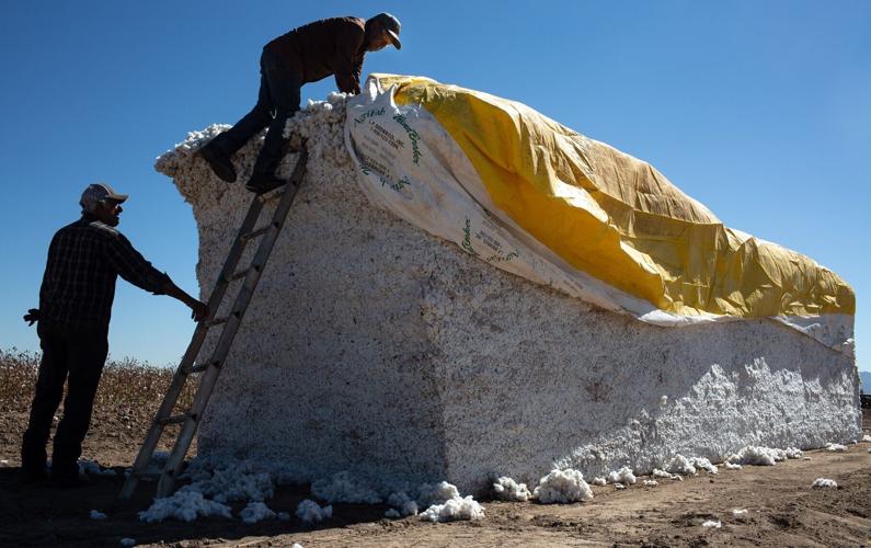
Farmhands wrap a bale of cotton in a tarp while harvesting at the Pacheco Farm in Marana in October 2020. Roughly 1,150 acres of cotton were harvested in Pacheco's fields that year. Alfalfa and cotton, both big water users, are grown on more acreage than any other Arizona crop.

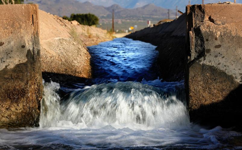
Water flows through a farm irrigation channel along Marana Road. Farms account for at least 70% of Arizona's total water use.

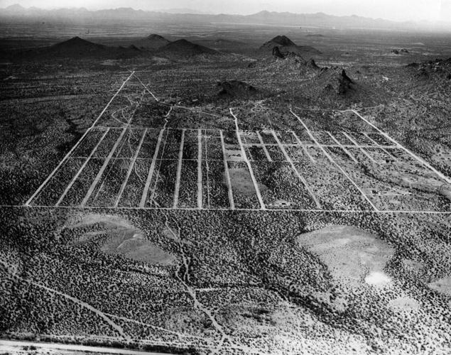
Dirt roads outline a planned subdivision in the desert southwest of Mission Road in Tucson in 1953. Until 1992, when Colorado River water arrived via the Central Arizona Project, there were concerns the growing metropolis of Tucson would pump the aquifer dry.

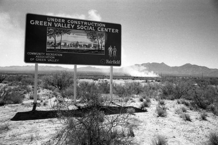
Sign announcing the Green Valley Social Center in June 1975. The CAP canal doesn't extend to Tucson's southern suburbs, which depend on groundwater pumping. As the Southwest's water woes intensify, experts worry that more ancient groundwater will be used up and not replaced.

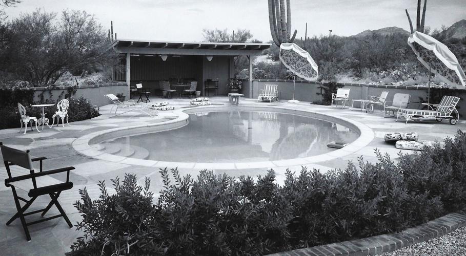
A home with a pool in the Tucson desert in 1960. Private pool numbers have grown steadily here as the population boomed, but now there's talk about whether pool covers should be required in order to reduce evaporation.
The Central Arizona Project is a 336-mile canal in Arizona that supplies Colorado River water for the Phoenix and Tucson area, agriculture and several Native-American tribes. Construction began in 1973 and was substantially complete by 1994. This portion is located near Sandario Road and Mile Wide Road west of Tucson on March 17, 2021. Video by: Mamta Popat / Arizona Daily Star

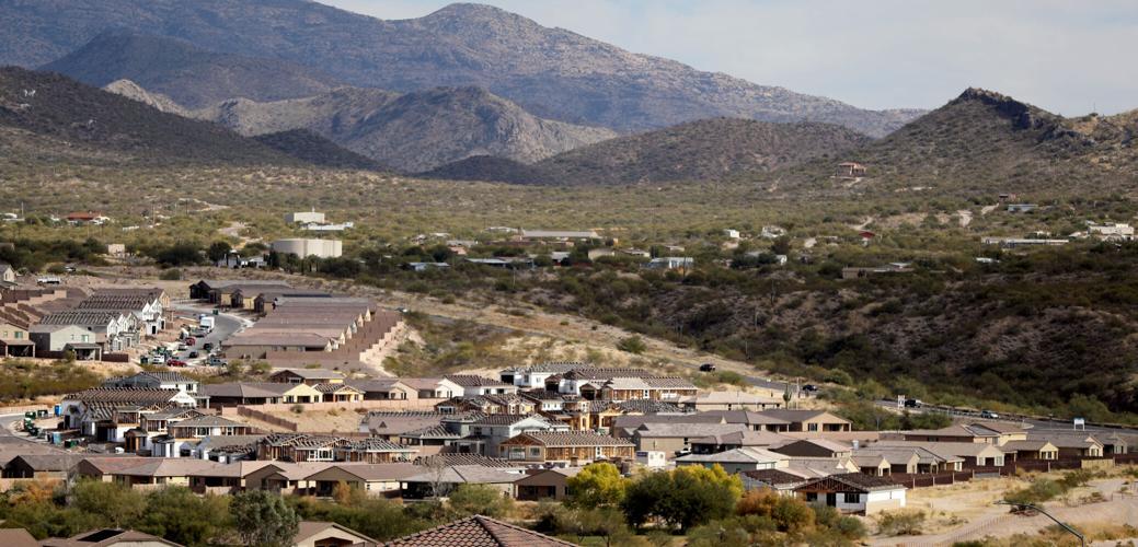
New homes now under construction in Rancho Del Lago along Colossal Cave Road in Vail. As our water crisis deepens, "It’s not required that we limit growth; I do think that conservation needs to be a much larger part of the equation," says Kathy Jacobs, a University of Arizona climate scientist.

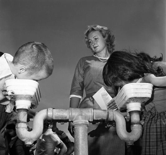
Students at Mission View Elementary School in Tucson stand in line in 1960 for a drink of water in the late summer heat. Today, Tucsonans use significantly less water per person than do those in Phoenix, Los Angeles, Las Vegas and Albuquerque.

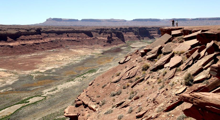
A couple of sightseers take in the view from Hite Overlook, where the Colorado River enters what was once the upper reaches of Lake Powell. Now dry, Hite Marina has been closed by the National Park Service.
Longtime Arizona Daily Star reporter Tony Davis talks about the viability of seawater desalination and wastewater treatment as alternatives to reliance on the Colorado River.

Photos: The receding waters of Lake Powell, Glen Canyon National Recreation Area

Tom Wright hikes past the beached marker for Willow Canyon where it joins with the Escalante River, Glen Canyon National Recreation Area, Utah.

A big horn sheep stands with the moon as a backdrop, looking over Fiftymile Creek, Glen Canyon National Recreation Area, Utah.

Tom Wright walks through the shaft of light peeking through the narrow openings of the formation called the Subway in Fiftymile Creek, accessible since the waters of Lake Powell have fallen dramatically.

A narrow sliver of sky is visible overhead through the narrow opening of the formation called the Subway, Fiftymile Creek, accessible since the waters of Lake Powell have fallen dramatically.

The dark streaking, called Desert Varnish, is from the seepage of oxidation in the rocks, and is beginning to erase the "bathtub ring", the lighter colored marks left by the waters of Lake Powell on canyon walls, Fiftymile Creek, Glen Canyon National Recreation Area, Utah.

The remains of a small boat, underwater for years, reemerges due to receding water levels of Lake Powell in the Glen Canyon National Recreation Area, Utah.

Frank Colver makes his way over the dried and cracking silt left where the Escalante River joins Lake Powell, Glen Canyon National Recreation Area, Utah. The receding water of the lake has the river cutting through the decades of accumulated silt to form a delta where it meets the lake.

A warning buoy sits high and dry far from the end of the closed public boat ramp at Bullfrog Bay, Glen Canyon National Recreation Area.

A line of tires that were once breakwaters at Bullfrog Bay Marina are now stranded on the rocky landscape high above the current water levels at the Glen Canyon National Recreation Area, Utah.

A pedestrian ramp lies well above the water levels at Bullfrog Bay in the Glen Canyon National Recreation Area, Utah.

A stranded wakeless zone buoy sits on the cracking silt outside the new shores of the Bullfrog Bay Marina, Glen Canyon National Recreation Area, Utah.

The end of the ferry ramp ends well short of the new water levels of Bullfrog Bay on the Glen Canyon National Recreation Area, Utah.

An early riser watches the sun come over the low waters of Bullfrog Bay Marina, Glen Canyon National Recreation Aria, Utah. The lighter colored areas on the canyon wall mark previous water levels.

A group of river rafters drift west on the current of the San Juan River outside Mexican Hat. The San Juan feeds Lake Powell.

The tops of a few cottonwood trees begin to poke out of shrunken water of Lake Powell, Fiftymile Creek, Glen Canyon National Recreation Area, Utah.

The remaining large water craft and house boats are crowded together in one of the last areas of water deep enough to support them at Wahweap Mariana, Glen Canyon National Recreation Area, Page, Ariz.

The waters of Lake Powell are twenty to thirty feet below the end of the public boat ramp at Wahweap Mariana, Glen Canyon National Recreation Area, Page, Ariz. Personal non-powered craft still use the ramp to unload, but must be carried up and down the banks to reach the water.

A view north from the Wahweap Marian Overlook show the shrunken waters around the marina in Glen Canyon National Recreation Area, Page, Ariz.

The underside of Gregory Natural Bridge, passable for the first time in almost 50 years, over the Fiftymile Creek, Glen Canyon National Recreation Area, Utah.

The moon rises over Gregory Natural Bridge, passable for the first time in almost 50 years, over the Fiftymile Creek, Glen Canyon National Recreation Area, Utah.

The exposed penstocks (intakes to the power turbines) on Glen Canyon Dam in the Glen Canyon National Recreation Area, Page, Ariz. The water level is at its lowest since 1967, when the dam was still being initially filled.

A group of sightseers get a look at the Glen Canyon Dam during a boat tour of Lake Powell, Glen Canyon National Recreation Area, Page, Ariz.

A small fishing boat ties up on the breakwater just outside the intakes for the Glen Canyon Dam, Glen Canyon National Recreation Area, Page, Ariz.. The penstocks (water intakes to the power turbines) are revealed for the first time since 1967 when the Lake Powell was being filled.

Swimmers and bathers use the jagged shores of the newly exposed banks of Lake Powell just above the Glen Canyon Dam, Glen Canyon National Recreation Area, Page, Ariz.

The Glen Canyon Bridge lies in front of electrical towers with feeder lines rising from the hydroelectric plant in the Glen Canyon Dam, Page, Ariz.

Glen Canyon Dam from Glen Canyon Bridge, Page, Ariz.

Small power boats on the Colorado River head upstream just below the Glen Canyon Dam, Page, Ariz.

Wade Quilter walks through the remains of cottonwood and Russian olive trees washed down and joined with silt to form a natural dam where Willow Canyon joins with the Escalante River, Glen Canyon National Recreation Area, Utah,

The remains of a big mouth bass lay in the silt just above where the Escalante River joins Lake Powell, Glen Canyon National Recreation Area, Utah.

The formation known as The Cathedral in the Desert on Clear Creek, Glen Canyon National Recreation Area, Utah. The re-emergence of the formation is drawing sightseers after being submerged for some 50 years.

Tom Wright feels the water oozing from the rocks in the formation known as Cathedral in the Desert on Clear Creek, Glen Canyon National Recreation Area, Utah. The re-emergence of the formation is drawing sightseers after being submerged for some 50 years.

Frank Colver takes a quiet moment and plays a handmade flute near the waterfall in the formation known as Cathedral in the Desert on Clear Creek, Glen Canyon National Recreation Area, Utah. The re-emergence of the formation is drawing sightseers after being submerged for some 50 years.

Jake Quilter walks down the newly cut banks of Clear Creek just outside Cathedral in the Desert, Glen Canyon National Recreation Area Utah. The sand is silt left behind by the receding waters of Lake Powell.

The tops of cottonwood trees that used to be under a hundred feet of water in Lake Powell are visible again in Clear Creek, Glen Canyon National Recreation Area, Utah. The deep water preserved the remains of the trees.

Boaters have to zig-zag through the rocks emerging due to receding waters of Lake Powell, Glen Canyon National Recreation Area, Page, Ariz.

Several images combined for a panoramic view of the Colorado River where it runs through the what once was Hite Marina in the Glen Canyon National Recreation Area, Utah.

A couple of sightseers take in the view from Hite Overlook over the Colorado River and the closed Hite Marina, Glen Canyon National Recreation Area, Utah.

Lone Rock, jutting out of the dry bed, would usually be surrounded by Lake Powell but is now well clear of the water, Glen Canyon National Recreation Area, Utah.

Tires that used to hold the lines well below the surface of Lake Powell are suspended over the water at Antelope Point Marina, Ariz.

Sightseers twenty or thirty feet above get photos of the low water levels of Lake Powell from the public boat ramp at Antelope Point Marina, Ariz.

The pedestrian access ramp ends abruptly twenty feet over the new Lake Powell surface at Antelope Point Marina, Ariz.

The entrance to the pedestrian access ramp of the Antelope Point Marina is taped off after being cutoff from the docks due to receding waters of Lake Powell.
Contact Tony Davis at 520-349-0350 or tdavis@tucson.com. Follow Davis on Twitter@tonydavis987.