
Editor's note: This is the third of six stories for "Colorado River reckoning: Not enough water," an investigative series by the Arizona Daily Star that observes, at length, the future of the Colorado River.
People are also reading…

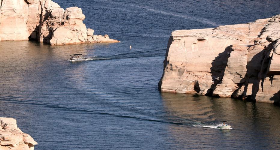
Boaters have to zigzag through the rocks reemerging from the falling waters of Lake Powell. In 2021 the lake drew more than 3 million recreators, the 25th highest annual visitor total at any National Park Service unit.

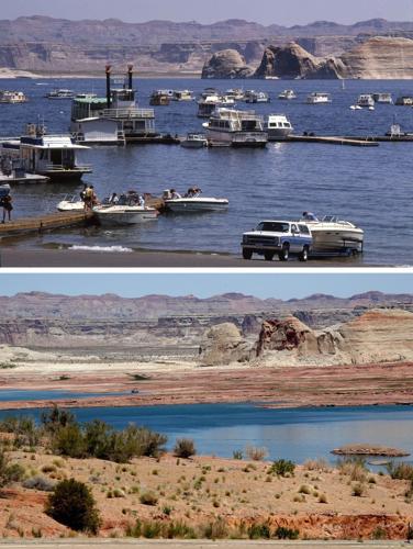
Looking northeast from Wahweap Marina public boat ramp at Lake Powell in 1986, top, and 2022.

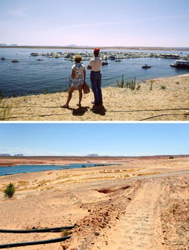
Wahweap Marina overlook at Lake Powell in 1986, top, and 2022.

Looking southeast from above the Wahweap Marina rental docks on Lake Powell in 1986, top, and 2022.
As water in one of the nation's largest reservoirs recedes, geologic features hidden for nearly 50 years are revealed in Glen Canyon National Recreation Area in Northern Arizona. Video courtesy of Glen Canyon Institute, 2022

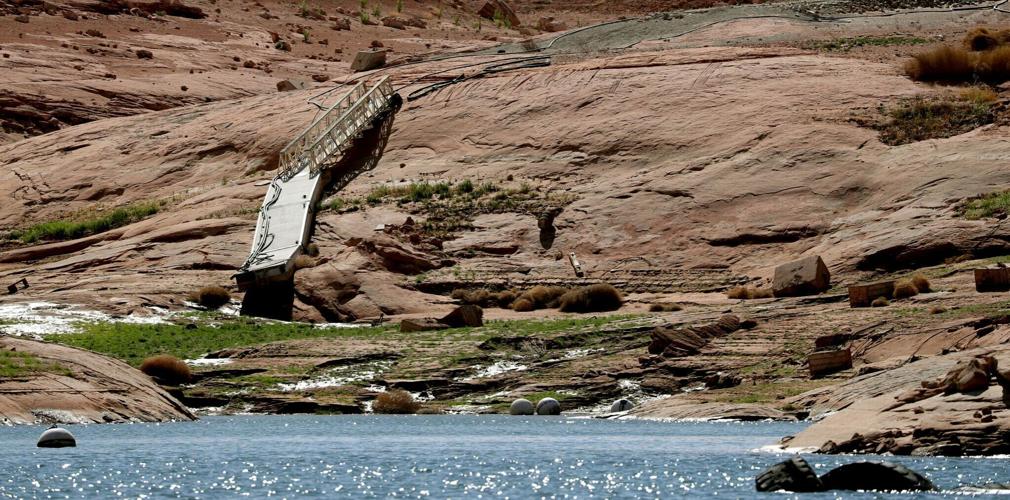
A pedestrian ramp draped across the landscape well above the water levels at Bullfrog Bay in Glen Canyon National Recreation Area in 2022.

Aerial image of Rainbow Bridge in 1962-'64 before flooding of Forbidding Canyon and Lake Powell. Ironically, that flooding improved access to the natural wonder. But today —conversely — as the water recedes, getting to the bridge is much harder again.

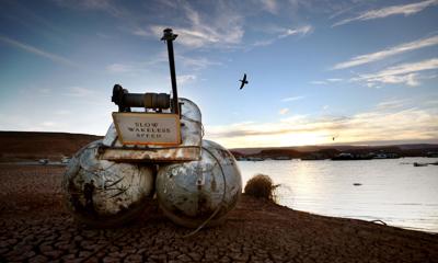
A stranded buoy sits on the cracking silt on the bottom of Lake Powell near Bullfrog Bay Marina in Glen Canyon National Recreation Area. Bullfrog's boat ramp has been closed off and on over the last 18 months as the lake shrinks.

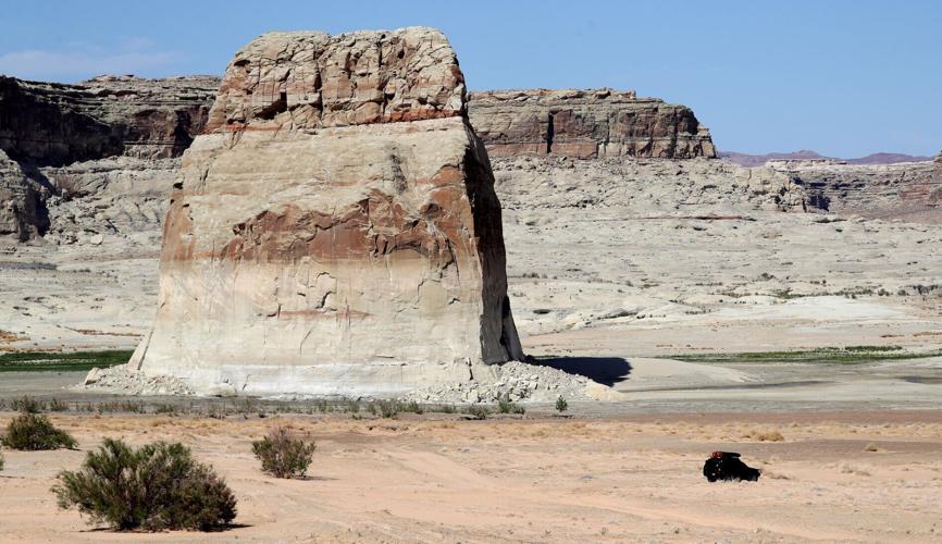
Lone Rock, jutting out of the now dry Lake Powell, would usually be surrounded by water.

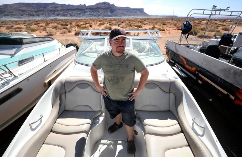
Robert Wilkes, owner of Skylite Rentals in Big Water, Utah, says closure of boat ramps at nearby Lake Powell is a drain on the economy. “Last year I was down $230,000 in cancellations,” he says.

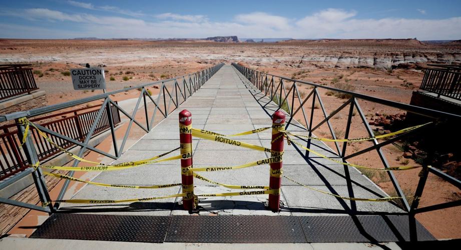
The entrance to the Antelope Point Marina pedestrian ramp is taped off due to lack of water in Lake Powell.

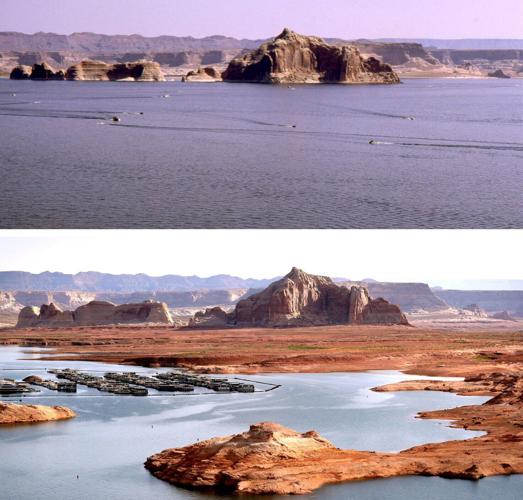
Photos: The receding waters of Lake Powell, Glen Canyon National Recreation Area

Tom Wright hikes past the beached marker for Willow Canyon where it joins with the Escalante River, Glen Canyon National Recreation Area, Utah.

A big horn sheep stands with the moon as a backdrop, looking over Fiftymile Creek, Glen Canyon National Recreation Area, Utah.

Tom Wright walks through the shaft of light peeking through the narrow openings of the formation called the Subway in Fiftymile Creek, accessible since the waters of Lake Powell have fallen dramatically.

A narrow sliver of sky is visible overhead through the narrow opening of the formation called the Subway, Fiftymile Creek, accessible since the waters of Lake Powell have fallen dramatically.

The dark streaking, called Desert Varnish, is from the seepage of oxidation in the rocks, and is beginning to erase the "bathtub ring", the lighter colored marks left by the waters of Lake Powell on canyon walls, Fiftymile Creek, Glen Canyon National Recreation Area, Utah.

The remains of a small boat, underwater for years, reemerges due to receding water levels of Lake Powell in the Glen Canyon National Recreation Area, Utah.

Frank Colver makes his way over the dried and cracking silt left where the Escalante River joins Lake Powell, Glen Canyon National Recreation Area, Utah. The receding water of the lake has the river cutting through the decades of accumulated silt to form a delta where it meets the lake.

A warning buoy sits high and dry far from the end of the closed public boat ramp at Bullfrog Bay, Glen Canyon National Recreation Area.

A line of tires that were once breakwaters at Bullfrog Bay Marina are now stranded on the rocky landscape high above the current water levels at the Glen Canyon National Recreation Area, Utah.

A pedestrian ramp lies well above the water levels at Bullfrog Bay in the Glen Canyon National Recreation Area, Utah.

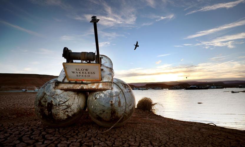
A stranded wakeless zone buoy sits on the cracking silt outside the new shores of the Bullfrog Bay Marina, Glen Canyon National Recreation Area, Utah.

The end of the ferry ramp ends well short of the new water levels of Bullfrog Bay on the Glen Canyon National Recreation Area, Utah.

An early riser watches the sun come over the low waters of Bullfrog Bay Marina, Glen Canyon National Recreation Aria, Utah. The lighter colored areas on the canyon wall mark previous water levels.

A group of river rafters drift west on the current of the San Juan River outside Mexican Hat. The San Juan feeds Lake Powell.

The tops of a few cottonwood trees begin to poke out of shrunken water of Lake Powell, Fiftymile Creek, Glen Canyon National Recreation Area, Utah.

The remaining large water craft and house boats are crowded together in one of the last areas of water deep enough to support them at Wahweap Mariana, Glen Canyon National Recreation Area, Page, Ariz.

The waters of Lake Powell are twenty to thirty feet below the end of the public boat ramp at Wahweap Mariana, Glen Canyon National Recreation Area, Page, Ariz. Personal non-powered craft still use the ramp to unload, but must be carried up and down the banks to reach the water.

A view north from the Wahweap Marian Overlook show the shrunken waters around the marina in Glen Canyon National Recreation Area, Page, Ariz.

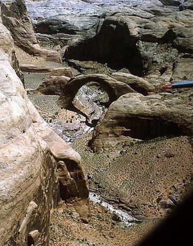
The underside of Gregory Natural Bridge, passable for the first time in almost 50 years, over the Fiftymile Creek, Glen Canyon National Recreation Area, Utah.

The moon rises over Gregory Natural Bridge, passable for the first time in almost 50 years, over the Fiftymile Creek, Glen Canyon National Recreation Area, Utah.

The exposed penstocks (intakes to the power turbines) on Glen Canyon Dam in the Glen Canyon National Recreation Area, Page, Ariz. The water level is at its lowest since 1967, when the dam was still being initially filled.

A group of sightseers get a look at the Glen Canyon Dam during a boat tour of Lake Powell, Glen Canyon National Recreation Area, Page, Ariz.

A small fishing boat ties up on the breakwater just outside the intakes for the Glen Canyon Dam, Glen Canyon National Recreation Area, Page, Ariz.. The penstocks (water intakes to the power turbines) are revealed for the first time since 1967 when the Lake Powell was being filled.

Swimmers and bathers use the jagged shores of the newly exposed banks of Lake Powell just above the Glen Canyon Dam, Glen Canyon National Recreation Area, Page, Ariz.

The Glen Canyon Bridge lies in front of electrical towers with feeder lines rising from the hydroelectric plant in the Glen Canyon Dam, Page, Ariz.

Glen Canyon Dam from Glen Canyon Bridge, Page, Ariz.

Small power boats on the Colorado River head upstream just below the Glen Canyon Dam, Page, Ariz.

Wade Quilter walks through the remains of cottonwood and Russian olive trees washed down and joined with silt to form a natural dam where Willow Canyon joins with the Escalante River, Glen Canyon National Recreation Area, Utah,

The remains of a big mouth bass lay in the silt just above where the Escalante River joins Lake Powell, Glen Canyon National Recreation Area, Utah.

The formation known as The Cathedral in the Desert on Clear Creek, Glen Canyon National Recreation Area, Utah. The re-emergence of the formation is drawing sightseers after being submerged for some 50 years.

Tom Wright feels the water oozing from the rocks in the formation known as Cathedral in the Desert on Clear Creek, Glen Canyon National Recreation Area, Utah. The re-emergence of the formation is drawing sightseers after being submerged for some 50 years.

Frank Colver takes a quiet moment and plays a handmade flute near the waterfall in the formation known as Cathedral in the Desert on Clear Creek, Glen Canyon National Recreation Area, Utah. The re-emergence of the formation is drawing sightseers after being submerged for some 50 years.

Jake Quilter walks down the newly cut banks of Clear Creek just outside Cathedral in the Desert, Glen Canyon National Recreation Area Utah. The sand is silt left behind by the receding waters of Lake Powell.

The tops of cottonwood trees that used to be under a hundred feet of water in Lake Powell are visible again in Clear Creek, Glen Canyon National Recreation Area, Utah. The deep water preserved the remains of the trees.

Boaters have to zig-zag through the rocks emerging due to receding waters of Lake Powell, Glen Canyon National Recreation Area, Page, Ariz.

Several images combined for a panoramic view of the Colorado River where it runs through the what once was Hite Marina in the Glen Canyon National Recreation Area, Utah.

A couple of sightseers take in the view from Hite Overlook over the Colorado River and the closed Hite Marina, Glen Canyon National Recreation Area, Utah.

Lone Rock, jutting out of the dry bed, would usually be surrounded by Lake Powell but is now well clear of the water, Glen Canyon National Recreation Area, Utah.

Tires that used to hold the lines well below the surface of Lake Powell are suspended over the water at Antelope Point Marina, Ariz.

Sightseers twenty or thirty feet above get photos of the low water levels of Lake Powell from the public boat ramp at Antelope Point Marina, Ariz.

The pedestrian access ramp ends abruptly twenty feet over the new Lake Powell surface at Antelope Point Marina, Ariz.

The entrance to the pedestrian access ramp of the Antelope Point Marina is taped off after being cutoff from the docks due to receding waters of Lake Powell.
Contact Tony Davis at 520-349-0350 or tdavis@tucson.com. Follow Davis on Twitter@tonydavis987.